
How We Do (not) Implement the Water Framework Directive in Improving the Morphological Status of Wat
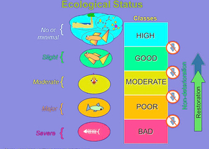
Data show that, in the 1990s, 28.4% of the total length of the Czech Republic’s watercourses were unfavourably modified, which is tens of thousands of kilometres of the river network. According to the current National Biodiversity Strategy of the Czech Republic, the country’s current optimistic targets are at least 300 km of restored watercourses for the 2016–2025 period. The status of watercourses and related floodplains has therefore not seen any significant improvement since the 1990s. Compared with biological and physical/chemical quality elements, monitoring and enhancement of the morphological status of the country’s watercourses has enjoyed a less significant position in the long term. However, apart from the “aesthetical” point of view, its improvement is also of unquestionable importance in terms of water retention in the landscape, flood protection, and drought management. It is therefore a topical issue in society.
Nature Conservation 2021 — 10. 6. 2021 — Research, Surveys and Data Management — Print article in pdf
The Latest Epigraphic Research Has Shifted back the Age of the Oldest Cave Drawing Traces in the Cze
Since 2016, epigraphic research has been carried out in the caves of the Moravský kras/Moravian Karst (South Moravia), with the participation of the Cave Administration of the Czech Republic (CACR), Palacký University Olomouc (PU), and the Nuclear Physics Institute of the Czech Academy of Science Prague (NPI CAS). In 2019, the surprising results of radiocarbon dating of some black charcoal drawing traces in the Kateřina Cave had revealed them to be of prehistoric age (approx. 6,300 years). For more details, see Ochrana přírody/Nature Conservation Journal, 74, 5, 39-41, 2019. During detailed documentation of these objects, some other interesting clusters of lines and shapes were discovered there. Analysis of one of them revealed that they are even older, namely more than 7,000 years.
Nature Conservation 2021 — 10. 6. 2021 — Research, Surveys and Data Management
Assessing Clogging the Dobroměřice Fishpond by Sediments
Particularly in farmland, there are consequences of erosion and soil transportation into watercourses and further to fishponds and water reservoirs. How to correctly assess the current state of a river basin/catchment areas and of a reservoir and to identify the sources of pollution? Therefore, for proposing appropriate conservation measures both in the landscape and directly on watercourses, mathematical modelling can be successfully combined with Geographic Information Systems (GIS), remote sensing and photogrammetry.
When surveying a site, archive data of aerial photography it is a good resource, and Unmanned Aerial Vehicles (UAVs) or drones are useful, both for making overview images and for photogrammetric processing of a ortophotomaps, or of a detailed surface model
Nature Conservation 2021 — 10. 6. 2021 — Research, Surveys and Data Management — Print article in pdf