
Nature Conservation 2021 — 10. 6. 2021 — Research, Surveys and Data Management — Print article in pdf
Assessing Clogging the Dobroměřice Fishpond by Sediments
Particularly in farmland, there are consequences of erosion and soil transportation into watercourses and further to fishponds and water reservoirs. How to correctly assess the current state of a river basin/catchment areas and of a reservoir and to identify the sources of pollution? Therefore, for proposing appropriate conservation measures both in the landscape and directly on watercourses, mathematical modelling can be successfully combined with Geographic Information Systems (GIS), remote sensing and photogrammetry.
When surveying a site, archive data of aerial photography it is a good resource, and Unmanned Aerial Vehicles (UAVs) or drones are useful, both for making overview images and for photogrammetric processing of a ortophotomaps, or of a detailed surface model
Description of the area and basic characteristics
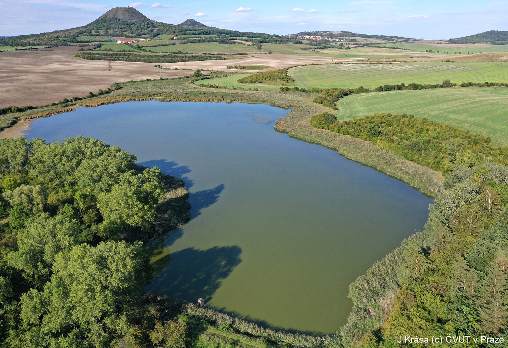
The Dobroměřice Fishond (Fig. 1) is a unique water body with extensive littoral vegetation within the dry steppe part of the Lounské středohoří/Louny Uplands. In terms of aquatic and semi-aquatic vertebrates, it is one of the most valuable areas in the whole České středohoří/Bohemian Uplands Protected Landscape Area (PLA). In addition, it is a very important nesting site for waterfowl, with a number of rare species associated with riparian areas with shallow submerged vegetation offering sufficient food and nesting availability. It is an equally important site as a stopover during spring and autumn migration for birds (long-term capture site), again mainly due to its location and the absence of similar sites in the wider region.
Figure 1: The Dobroměřice Fishpondand its catchment area with Oblík Hill
(509 m a.s.l.) on the horizon. © Josef Krása
According to the 2015–2024 Management Plan for the České středohoří/Bohemian Uplands PLA, the Dobroměřický rybník site is proposed to be declare as a new Specially Protected Area, mainly due to its extremely high natural science value. A very important factor in the site´s quality is the low fish stock. For further negotiations with the entities concerned, it is necessary to know the degree of siltation and sediment movement sediment into the site. These findings will be a necessary background for the NCA CR to outline a longer-term proposal for management of the entire site and protection of its species richness.

The subject of the study is mapping sediments in the fishpond, determining the rate of clogging with regard to erosion and transport processes in the catchment area, and identifying sources of surface pollution from erosion processes. The fishpond is within the property of Rybářství Třeboň/Třeboň Fishery Hld. Plc, to whom Rybářství Mariánské Lázně/Marienbad Fishery Ltd. leases the pond as a fry or nursery fishpond, not as a main or production/harvest pond.
The Dobroměřice Fishpond catchment area is located in the District of Louny, extends into the cadastral areas of Dobroměřice, Nečichy, Raná u Loun, and Chraberce, covering a total of 906.5 ha. Farmland occupies a total of 678 ha, i.e. almost 75% of the catchment area. The vast majority of the remaining land consists of forest and scrub on peaks on the catchment area watershed. Thanks to its fertile soil and favourable climate, the entire area has long been intensively used for agriculture.
As far as agricultural land is concerned, arable land currently (2019) covers 544.65 ha (80% of Agricultural Land Resources) and consists of 65 plots, according to the Land Parcel Information System (LPIS) records. Permanent grasslands occupy 117.7 ha, vineyards 2.12 ha, orchards 1.62 ha, and there are about 12 ha of gardens around the built-up area (Fig. 2).
Although these are not particularly steep areas, the manifestations of excessive erosion processes and subsequent damaged and washed away soils are clearly visible from aerial photographs (Fig. 3). The vast majority of soils in the Dobroměřice Fishpond catchment area can be characterized as non-structural, fine-grained, and not very cohesive. Such soils are difficult to cultivate, but very fertile for agricultural production. However, from an erosion point of view, it is a very dangerous material because such soils usually have very low permeability, but at the same time they are easily leached.

Figure 3: The north-east part of the catchment area, washed-out soils and
the character of the tributary bed. © Josef Krása
Current state of the Dobroměřický rybník and its catchment area
According to available map data, the Dobroměřice Fishpond catchment area has been intensively used for agriculture since time immemorial. Throughout the period for which relevant map data are available (more than 200 years), land use has remain approximately the same and it is clear that the proportion of forest and grassland has not been higher in the past than today.
The situation around the development of Dobroměřice Fishpond itself is surprisingly dynamic. As documented by the historical maps and aerial photographs below (Fig. 4), the fishpond had been there at least before 1850 (in approx. its current dimensions). However, 1937 images show that the floodplain was drained and the area was used as agricultural land. Soon after that (documented by a picture from 1952), the area was re-wetted and economic use limited or even excluded – the area is wet and lying fallow. Subsequently, even before 1989, the fishpond is again mentioned on the map as a free water surface, which has been gradually getting smaller in the last 20 years due to the growing littoral zone and the influence of infill by sedimentation.

The Dobroměřice Fishpond itself currently has an extensive littoral zone around the open water surface. However, it is not entirely clear whether this is a wet area around the original fishpond capacity or a sedimented part of the original fishpond capacity.
Part of the described study was also a detailed survey of the fishpond catchment area in order to identify obvious traces of erosion and transport processes.
No direct traces documenting the current erosion or transport and deposition of erosive alluvium were found by field survey; however, long-term erosive damage to agricultural soils is clearly documented by aerial photographs – see e.g. Figure 5.
However, all watercourses in the catchment area are intensively cultivated up to the bank edge without any vegetation protection against the entry of eroded material from fields. Any inflowing material has free entrance to the fishpond. Smaller water reservoirs in the catchment area are heavily clogged and cannot fulfil any capture function.

The next step was to measure the volume of water and sediment in the reservoir from a boat with a draft of 10 cm, using a depth gauge and probe; the measurement points were recorded with an accuracy in units of cm using Real-time kinematic positioning GPS. The volume of sediment in the area of the current flood (Fig. 6 – September 2019 – marked in blue – 7.42 ha) is 54,260 m3. The total volume of sediment in the floodplain identified in 2008-2017 (marked in brown – 8.06 ha) is 58,815 m3.

The water depth at the time of the survey (August 2019) ranged from 134 cm at the dam to 10 cm at the littoral border, where it was possible to get with the boat. The average water depth calculated from the area of the current water surface was only 26 cm; a large part of the area is up to 20 cm deep (see Fig. 7).
During the measurements, samples were taken from the sediment surface layer to a depth of 20 cm, and then a homogenized mixed sample of sediment was formed to determine its bulk density and nutrient content. The bulk density of sediment in the Dobroměřice Fishpond is on average 1,269 kg/m3; thus, the total volume of sediment 54,260 m3 accounts for 68,856 tons of deposited sediment.
Determination of the total organic carbon (TOC) content and total phosphorus was performed by the accredited laboratory of the Povodí Vltavy/Vltava River Basin Management Authority, State Enterprise. The TOC values are 50 g/kg dry weight and the total phosphorus 840 mg/kg dry weight.
The result shows that it is a highly organogenic sediment, which can contain up to 58 tons of total phosphorus (an extremely high load). The fact suggests that a significant part of the deposited material consists of decomposing plant residues directly from the fishpond area. In contrast, the bulk density of around 1,300 kg/m3 also confirms the presence of a mineral (erosion) component.
Sediment transport in the catchment area in 2019
The distributed mathematical model WaTEM/SEDEM was used for the calculation, successfully tested and validated for use in the Czech conditions on a number of experimental and case studies. The mathematical model calculates the average annual soil loss based on the Revised Universal Soil Loss Equation and includes transport and deposition of eroded material within the catchment area (Krása et al. 2013).
Overall results of the model for the current management of agricultural land (2019) show significant values for long-term land loss (a total of 4372 t/year), or an average value of 7.47 t/ha/year on arable land, which is the largest source of eroded material.
To interpret the calculated values, it is necessary to recognise that the vast majority of material (97%) which is released from farmland (erosion) settles in the catchment area (deposition), i.e. before entering watercourses. Thus, the part of the material is not directly involved in clogging the stream or fishpond; however, it causes problems locally at the points of removal or deposition. In other words, it seriously damages agricultural land. High risk sites for excessive transport in the catchment area can be seen in red on the map (Fig. 8). On a long-term average, every year approximately 80 tons of sediment reaches the Dobroměřice Fishpond via watercourses.

What are the conclusions?
The results of the calculation presented above show that the erosion processes in the area of interest are highly developed; it is an important degradation factor in terms of soil protection. The average values of land loss (both on arable land and on all the Agricultural Land Resources significantly exceed the recommended limits of permissible land loss, i.e. 4 t/ha/year). The average loss on arable land in the catchment area is 7.5 t/ha/year. On the other hand, the use of a fully distributed mathematical model (WaTEM/SEDEM), which includes a description of deposition processes in the catchment area, has shown that a significant part of erosion alluvium is captured directly within the catchment area and does not reach watercourses.
Transport of erosive alluvium to the fishpond is thus essentially done exclusively by its tributaries, of which the branched network to the east of the fishpond is clearly more important, as confirmed by the calculation and field research.
The input of erosive sediments can be effectively reduced below the current value – in principle in three possible ways:
- Introducing protective measures directly onto potential source areas;
- Creating good quality and well maintained protective grass belts along watercourses;
- Constructing collection tanks (sedimentation traps) on both tributaries of the Dobroměřice Fishpond (the SE branch is more important).
The outlook for the next decade can be formulated as follows:
The fishpond will slowly clog up, mainly from the tributary and in the entire littoral zone. In the area of the tributary, the input of erosive sediments from the catchment area will have a decisive influence; in the whole remaining area of the littoral, organic material from dead vegetation will be decisive. Due to the minimum water depth and water deficit in the catchment area in the summer months, it is possible to expect water level fluctuations in the future and, therefore, faster spread of emergent vegetation (reeds) into the existing free water surface; this is because the water depth would probably already allow the type of vegetation to grow, as seen for example at the time of the research. The process is also supported by extremely trophic sediment covering the entire bottom of the fishpond.
In its current state, the fishpond is basically unable to fulfil its fish farming function and, due to the declining volume of retained water and its minimum depth, it is extremely susceptible to fluctuations in water level and significant variability of water surface area during droughts and torrential rain. Related to this are the risks of fluctuations in oxygen level and transitions to anoxia or anaerobia – a condition that is not suitable for fish and many other organisms.
In the case of mud removal, it is first necessary to limit the input of erosive sediments from the catchment area into the fishpond.
The Dobroměřice Fishpond is a good example of a valuable site, created historically thanks to human activity in an otherwise extremely intensively agriculturally used landscape. At present, however, both its economic functions (fish farming) and probably also its natural functions (site with a free water surface) are endangered, partly due to intensive infill by sedimentation and partly due to high nutrient load. The problem of infill is technically relatively easy to solve with sufficient funds. However, the problem of nutrient input and retention is very difficult to manage in an intensively used agricultural landscape and would mean careful and demanding management of the fishpond itself with a system of protective equalizing reservoirs, or careful management of the entire catchment area, which could become a pilot site. According to CTU research, similarly problematic sites occur very often in the Czech Republic´s landscape.