
Nature Conservation 2025 — 31. 7. 2025 — On Nature in the Czech Republic — Print article in pdf
The Krušné hory/Ore Mountains Protected Landscape Area?
One of the tasks in the Programme Statement of the Government of the Czech Republic issued in March 2023 is the preparation of documents for the designation of the Krušné hory/Ore Mountains (also known as Erzgebirge) Protected Landscape Area in cooperation with the municipalities and regions concerned. So to what extent has the commitment been fulfilled just now when the Ministry of the Environment of the Czech Republic has announced its intention to designate the Krušné hory/Ore Mts. Protected Landscape Area as a public decree, and how long is the way to really achieving this goal?
Natural values
The Krušné hory/Ore Mountains are an approx. 120 km long mountainous area extending from the Jindřichovická vrchovina/Jindřichovice Highlands near the town of Luby in the southwest to the Nakléřovická hornatina/Nakléřovice Uplands near the village of Petrovice in the northeast. Due to Alpine rock folding, the south-eastern margin of the range was formed into a linear edge made by steep slopes of tectonically lifted plates or fault block. Over short distances, altitude differences often exceeding 600 m were created. The fault blocks are inclined to the northwest, where they gradually descend to lower positions. The state border with the Federal Republic of Germany is situated roughly on the range axis. The main ridge is flattened, creating plateaus with faint peaks of over 900 m in altitude. The highest part of the range is concentrated in the southwestern third, where it rises into a part with more prominent peaks exceeding the 1000 m mark and culminates in the Klínovec massif with Fichtelberg (1,214 m) as its highest peak in Germany and Klínovec (1,244 m) in Czechia. Towards the northeast, the ridge abruptly falls 200 m down to an adjacent peneplain. The peaks often show rock formations like rock walls and frost blocks, which are sometimes supplemented by more extensive block fields.

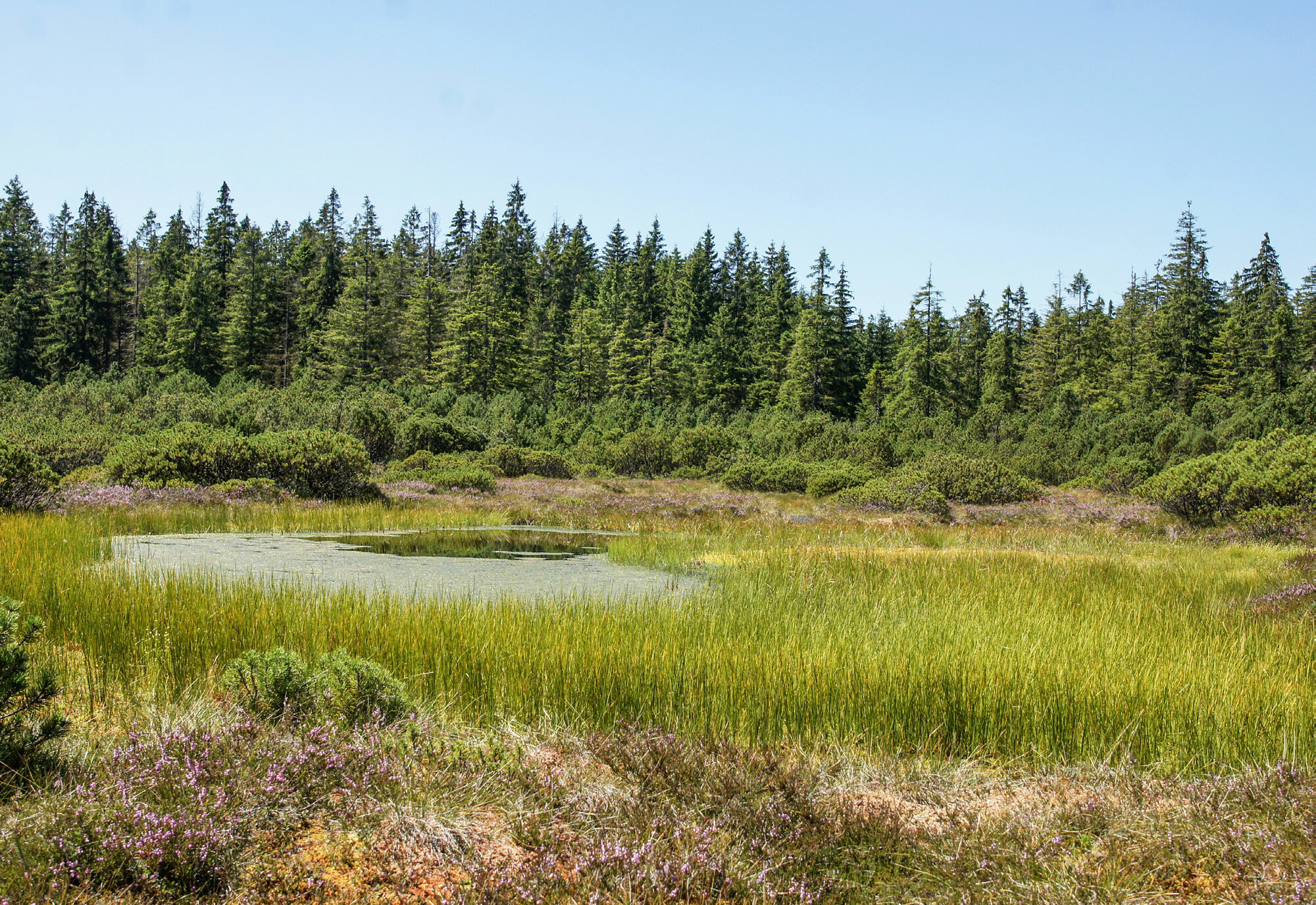
Peaty habitats are a typical part of the Krušné hory/Ore Mountains ecosystems. © Petr Krása
The Krušné hory/Ore Mts.’ climate is influenced by a prevailing westerly flow. Annual precipitation exceeds 1,000 mm and the mean annual temperature fluctuates between 4 and 6 °C, in the Mt. Klínovec area even lower. The range is mostly drained by streams which use transverse faults perpendicular to the long axis of the mountain ridge. The Saxon part is drained into the Mulde river, the Czech one into the Ohře/Eger and Bílina rivers. The shape of the plateau has given rise to large spring areas in the shallow floodplains of the upper streams and, together with the humid climate, has preconditioned the formation of peatbogs on the impermeable layers of the prevailing granite bedrock.
Raised peatbogs cover a total area of about 4,000 ha. Their character and extent are comparable to the iconic peatbogs of the Šumava/Bohemian Forest Mts. range. Raised peatbogs with dwarf pine, most often Pinus ×ascendens nothosubsp. skalickyi, prevail. Open peatbogs with ponds and gullies are less frequent, but are one of the best-preserved habitats there. The peat layer exceeds several metres in depth, and a depth of even 10.5 m has been measured in the Pod Novoveským vrchem peatbog. The typical raised-peatbog flora also includes relict occurrence of the Marsh Labrador tea (Ledum palustre), the Dwarf birch (Betula nana), and the Bog rosemary (Andromeda polifolia). The margins of the Velký močál pond are inhabited by the English sundew (Drosera anglica) and rarely also D. ×obovata. The bog sedge (Carex limosa) and more rarely also the Rannoch-rush (Scheuchzeria palustris) are typical of gully vegetation. The raised bogs are bordered by boggy and waterlogged spruce forests of various quality, often forming extensive complexes. Sporadically, the Interrupted club-moss (Lycopodium annotinum) grows there, even more rarely also the Lesser twayblade (Listera cordata). Boggy forests in shallow non-forest depressions are accompanied by many transitional peatbogs and spring fens. There the Common butterwort (Pinguicula vulgaris) rarely grows, in the more mineral-rich springs also for example the felworth Swertia perennis and the Hairy stonecrop (Sedum villosum), the Water blinks (Montia fontana subsp. Amporitana) grows scattered in grassy spring fens.

Mountainous landscape with scattered buildings in the surroundings of the village of Nové Hamry. © Petr Krása
Whereas peatbog habitats are concentrated in the western and central parts of the peneplain at the mountain ridge, the eastern half is much more covered by grassland communities, with habitats of montane oatgrass (Trisetum spp.) meadows and mesic button-grass (Arrhenatherum spp.) meadows prevailing at lower elevations. Valuable mountain meadows are however found all over the range. Typical species growing here include the Bald money (Meum athamanticum), a locally common plant, further the Black rampion (Phyteuma nigrum), the Broad-leaved meadow-grass (Poa chaixii), and the Wild pansy Viola tricolor subsp. polychroma). On the other hand, the steep slopes heading eastwards to Krušné hory/Ore Mountain basins are mostly covered with extensive beech forests accompanied by oak and oak-birch forests, especially in contact with the Ohře/Eger River in the central part. Acidophilous beech forests are the most widespread type of beech forest there. Part of them are among the best-preserved and largest beech stands of the Bohemian Massif, e.g. those in Jezerka National Nature Monument and Točník-Kapucín Nature Reserve. They include fragments of montane sycamore-beech forests often with typically twisted trees, while herb-rich beech forests grow at lower elevations. The species composition of the herb layers in broadleaved stands is very rich. Depending on habitat characteristics, the Martagon lilly (Lilium martagon), the Perennial honesty (Lunaria rediviva), the Bird’s nest orchid (Neottia nidus-avis), and the Large white buttercup (Ranunculus platanifolius) can be found growing there.
 is one of the rarest species. © Petr Krása")
The relict Dwarf birch (Betula nana) is one of the rarest species. © Petr Krása
Spruce forests, from cultural to reed grass (Calamagrostis spp.) stands occur throughout the mountain range, in the Mt. Klinovec massif also climactic mountain fern stands are found. The Alpine coltsfoot (Homogyne alpine) is a frequent plant species, while the Hard fen (Blechnum spicant) and the Clasping twistedstalk (Streptopus amplexifolius) are locally scattered. A rare plant to be mentioned is the One-flowered wintergreen (Moneses uniflora).
As the current vegetation is largely influenced by extensive mining activities in the past five centuries, vegetation of anthropogenic habitats is typical of the Krušné hory/Ore Mts., e.g. shrub communities of secondary heaths on spoil heaps, slag dumps, stone mounds, and larger areas abandoned after removing the surface cover for mining there. Rare species growing at such sites are the Wolf’s bane (Arnica montana) and several alpine clubmosses like Diphasiastrum alpinum, D. ×issleri, and D. ×zeilleri. A unique historical work of our ancestors is the Blatná water ditch, now a National Cultural Monument, which used to bring locally scarce water to the mine industry at Horní Blatná, at a distance of 20 km. Its course is inhabited by the strongly endangered Alpine pondweed (Potamogeton alpinus) occurring there almost continuously for several kilometres, probably being the species’ largest population in the Czech Republic.
An important specific environment linked to the mining history is the unimaginably vast underground of mined ore tunnels and large chambers together with surface phenomena such as sinkholes. Deep depressions in the surface look like a mountain karst environment in morphology and microclimate, although these habitats are species-poor. It is the shady and damp habitat of the depressions harbouring the Alpine blue-sow-thistle (Cicerbita alpine). The underground itself reveals the geological structure and is the proof of the Krušné hory/Ore Mts.’ mineralogical diversity linked to the mined ore wealth. This environment is also the winter habitat for more than 12 bat species, the rarest ones being the Northern bat (Eptesicus nilssonii)), Bechstein’s bat (Myotis bechsteinii), Geoffroy’s bat (M. emarginatus) and the very rare Pond bat (M. dasycneme).

Extensive heaths are typical habitats in the mining-altered landscape of the Krušné hory/Ore Mountains. © Petr Krása
The Grey wolf (Canis lupus) has regularly appeared over almost the entire length of the mountain range for several years and its current population can be considered stabilised there. On the Saxon side of the mountain range, a gradual reintroduction of Eurasian lynx (Lynx lynx) is being carried out.
Although the Western capercaillie (Tetrao urogallus) has probably disappeared finally from the mountains, the population of the related Black grouse (Lyrurus tetrix) seems to be stable over the long term. It is now regarded to be the largest in the Czech Republic despite that originally young substitute stands in clearings, which were suitable for the grouse, are disappearing and decaying, and the size of the Krušné hory/Ore Mts. local sub-populations are declining in many places.
Landscape values
Besides its high natural values, the landscape of the Krušné hory/Ore Mts. landscape displays a distinctive imprint of the past, making it picturesque and unique.
Eight hundred years of almost continuous extraction of polymetallic ores and minerals have given the Krušné hory/Ore Mts. their unique appearance. The combination of geographically variable mineral production, topography, and a predominantly state-controlled mining system has determined the exploitation of the landscape: mining, water management and transport, ore processing, settlement, forestry, and agriculture. The extraction of minerals has had a major impact on the form of settlements and landscape structure. Mining towns were initially mainly built unrestrainedly, and developed along with the mines. Later, in the 16th century, they were founded at greater distance from the mining areas and often as Renaissance towns with a large square-shaped square and streets and housing blocks in a chessboard arrangement (e.g. the municipalities of Horní Blatná, Mikulov, Výsluní, and Hora Svatého Šebestiána). In its most representative form, the Krušné hory/Ore Mts. landscape with remains of historical mining exploitation has been preserved and protected as a set of landscape conservation zones having been registered under the name Erzgebirge/Krušnohoří Mining Region as a UNESCO World Heritage Site since 2019. We can find there a range of specific features on the surface, mainly placer-mining and panning sites (groups of small mounds of sand and gravel formed by piling overburden material), surface outcrops (surface/open-pit quarries, depressions, sinkholes, etc.), shaft and gallery mouths, tailings, slag heaps, and spoil tips, but also under the ground, mainly galleries, tunnels, shafts, pits, and underground workings. Various mining objects, ore processing and smelting plants and mining water management facilities, including some unique well-preserved navigation channels, are also visible in the landscape.
 male. © Petr Šaj")
Black grouse (Lyrurus tetrix) male. © Petr Šaj
In the lower parts of the Krušné hory/Ore Mts., the settlement and landscape structure typical of local agricultural colonisation in the 12th to the 14th centuries has been preserved, i.e. villages with long strips of land (plužiny) running from farmsteads roughly perpendicular to the longitudinal axis of the village, from the valley up the wooded hills. Colonisation proceeded mostly upstream of watercourses forming the axis of the settlement, perpendicularly connected to large fields and pastures. This pattern has been preserved in many villages to this day. The course of the plužiny is often documented by walls, the so-called agrarian mounds created by collecting stones from the fields and depositing them on boundaries. Their form is varied, from loose stone banks through constructed stone banks and walls to clay or stone-clay terraces. Depending on local conditions and declining utilisation, they have usually become overgrown with trees and specific vegetation, and are distinctive linear vegetation elements and habitats for a range of wild animal and plant species. They provide the landscape with distinct aesthetic and make it one of the Krušné hory/Ore Mts.’ most valuable landscape types.

The proposed Krušné hory/Ore Mts. PLA and areas with enhanced nature conservation. © Jan Vrba

Preliminary Zonation Proposal of the Krušné hory/Ore Mts. PLA (2016) Divided into four zones based on natural and landscape characteristics. Expert basis for discussion with municipalities and land managers. © Jan Vrba
The Krušné hory/Ore Mountains from the nature conservation perspective
Large-scale protection of the Krušné hory/Ore Mts. has been under discussion for decades. One of the reasons why preparation of the designation of a protected area started only in 2022 is probably ‘bad reputation’. The mountain range was situated in a region strongly affected by industrial air pollution and mining industry, and some of the dead forests have been restored in an ecologically questionable way (soil preparation with bulldozers, massive planting of non-native tree species). In spite of this burden, extraordinary landscapes and natural phenomena have been preserved there. This is supported by the fact that more than half of the range is protected in some form, e.g. Sites of European importance (SEI, pursuant to Act No. 114/1992 on Nature Conservation and Landscape Protection, as amended later, the term for Site of Community Importance, SCI, later Special Area of Conservation, SAC, under the European Union’s Habitats Directive), Bird Areas (pursuant to the above act, the term for Special Protection Area, SPA under the EU Birds Directive), National Nature Reserves, Nature Reserves, Nature Monuments, and Nature Parks. The Krušné hory/Ore Mts. are also part of a protected natural water accumulation area. Nevertheless, they are the last large border range lacking comprehensive nature conservation in the Czech Republic, i.e. the mountain range as a whole is not a large-size Specially Protected Area. Pursuant to Act No. 114/1992 on Nature Conservation and Landscape Protection, as amended later, Site of Europena Importance, SEI is the term for Site of Community Importance, SCI, later Special Area of Conservation, SAC, under the European Union’s Habitats Directive), while Bird Area (BA) is pursuant to the above act, the term for Special Protection Area, SPA under the EU Birds Dirctive.
Progress in preparation of Protected Landscape Area designation
During the past two years, basic documents for the Protected Landscape Area (PLA) have been completed: a proposal for the delimitation of an area approx. 1,220 km² in size, a classification of the PLA into zones, and other analytical materials. The original PLA delimitation proposal and indicative zonation proposal are shown on Map 3. Zone I occupies approx. 13% of the PLA territory and overlaps with Natura 2000 network core areas, generally composed of robust peatland communities and extensive close-to-nature beech forests and mixed forest stands. The original proposal for Zone IV, where built-up and developable areas are concentrated, accounts for approx. 2.5% of the proposed PLA territory. The PLA boundaries and zone delimitations are being modified following discussions with local governments/municipalities and farmers.
Most common concerns and opinions
During the negotiations, several hundred questions and objections were raised. Most of the often repeated questions and answers (access to forests, forest fruit collection) are published at the website of the Nature Conservation Agency of the Czech Republic (NCA CR). We here comment on four conceptual suggestions in more detail: urban development in villages, renewable energy sources, especially wind farms, forest management, and the appropriateness of protecting the area as a PLA.

Rock gate in a beech forest on steep slopes near the Jezerka National Nature Reserve border. © Radek Fišer
 occurs at a few raised peat-bogs only. © Petr Krása")
The English sundrew (Drosera anglica) occurs at a few raised peat-bogs only. © Petr Krása
Urban development. Fears that it would not even possible to build a henhouse in the PLA have mostly been allayed. However, to limit these concerns, it was necessary to expand Zone IV and some settlements, and to exclude developable areas from the PLA based on land-use/territorial and spatial plans, although the opposite would certainly be better for cultivating the urbanisation of the complicated area. However, the complex negotiations have also provided the State Nature conservancy authorities with feedback on the direction of their activities within the area, particularly the emphasis that should be put on the regulatory elements of land-use/territorial and spatial plans and the thoughtful use of the institute of general measures, the content of which will be factually discussed with the municipalities. This will lead to a reduction in individual assessments of construction plans, most often in residential areas, which are of most interest to their residents and municipal representatives. Although these adjustments could be interpreted as too big concessions, they are rather a rational response to the development of social demands and a search for State Nature Conservancy’s priorities in landscape protection.
Renewable energy sources (RES). The approach to the development of wind energy is contradictory on the part of the municipalities. A critical view used to prevail, but this has changed during the two years of negotiations, e.g. in view of changes in opinion in the municipal councils. It must be emphasised that a PLA itself is not and cannot be an absolute barrier, but an area where public interest in the installation and development of wind power technology (WPT) must be unbiasedly assessed and weighed against other public interests, such as nature conservation and landscape protection. This has already been happening now, including reflection on the impact on the European Natura 2000 network. On the other hand, logically no protected areas are included into the so-called Acceleration Zones for RES development. One of the basic documents for the PLA management plan is a preventive landscape assessment study, identifying landscape segments where WPT development is acceptable from the perspective of nature conservation and landscape protection, and areas where this is inappropriate. The PLA management plan will then be the starting point for the preparation and updating of land-use/territorial and spatial planning documents.
There will be primeval/virgin forest everywhere. There is no rational basis for the fear that the PLA will lead to the creation of large areas covered by primeval/virgin forest like stands left to spontaneous development. PLAs are not established with this aim. The local forests have undergone a complex historical development, during which considerable areas have been planted with monocultures of (especially Norway spruce) trees, which were destroyed by heavy air pollution in the second half of the last century, and unfortunately partly also by ecologically questionable forest management in an attempt to restore them. Establishment of the PLA would certainly contribute to more nature-friendly management as a whole, including the valuable (mainly beech) forests on mountain slopes, and to restoration of other forest stands (either stands of substitute trees, or spruce monocultures) towards a more natural species and spatial diversity. Of course, as is already the case now, we cannot not rule out designating forests suitable for spontaneous development in appropriate places. The question whether local spruce stands will survive is not causally linked to the existence of a PLA, but will depend primarily on the approach of the foresters and development in climate.
What is better, a National Park or contractual protection? With regard to the effort to improve the management of the Krušné hory/Ore Mts.’ landscape and natural environment as a whole, including their cultural and historical values, a Protected Landscape Area is clearly the only relevant category of territorial protection. The fragments of close-to-nature communities are not large enough to designate a National Park therre. Its protection will be provided with appropriate PLA zonation, particularly by Zone I, the strictest protection regime. Contractual protection is completely irrelevant because of the protected area’s extent, its ownership and administrative structure and objectives, and any attempts to employ this tool would not result in improved nature protection, conservation and management under the local conditions, but in endless negotiations and a subsequent bureaucratic collapse. Contractual protection is appropriate in the case of relatively small to medium-sized segments of the natural environment with a low number of landowners, where ensuring purposeful management is essential for nature conservation. However, in relatively extensive areas, public law contracts under the provisions of Section 68 of the Act on Nature Conservation and Landscape Protection may be applied, which can appropriately replace contractual protection.
More than 100 meetings held during document preparation
In 2023 and 2024, about a hundred meetings on the planned designating a PLA were held with representatives of local governments (67 municipalities and 2 regions) and other interest groups (especially foresters). Although these were part of the preparation of technical documents and not primarily aimed at hearing the municipalities’ attitudes, it can be tentatively concluded from the discussions that most entities rather accept the intention declaring a PLA, while less than half did not express an opinion, and a minor part has fundamental reservations or disagree (however, the proportions are dynamic and have changed over time). For example on July 1, 2024, an important meeting was held between the NCA CR and representatives of local governments in the central part of the mountain range (Jáchymov, Loučná pod Klínovcem, Abertamy, Kovářská, Kryštofovy Hamry, Pernink, and by proxy also Horní Blatná), where several demanding negotiations led to a compromise acceptable to both parties instead of the originally negative opinion. Some other municipalities (e.g. Blatno, Hora Svatého Šebestiána, and Kalek), covering around 12% of the planned PLA’s territory, initiated the establishment of the Krušné hory/Ore Mountains Protected Landscape Area themselves, continually support it, and demand intensive activities on its preparation. A positive approach by the municipalities was also reflected in the requests to modify the zonation in favour of nature conservation, and finally, the Protected Landscape Area was even expanded according to an initiative by some municipalities to include the area around the village of Petrovice, which is separated by the D8 motorway but undoubtedly deserves to be part of the PLA.
Protected area development strategy in national and international context
The designation of the Krušné hory/Ore Mts. Protected Landscape Area (approx. 1,200 km²) would also be a major contribution to the fulfilment of the Czech Republic’s international and European Union obligations. According to the EU Biodiversity Strategy, the Member States should apply territorial nature protection on 30% of their territory (currently 22% in the Czech Republic) and strict protection should be implemented on one third of that, i.e. 10% (currently approx. 4%), by 2030. Designation of the Krušné hory/Ore Mts. PLA would also support better nature protection, conservation and management, as well as to a simplification and streamlining of public/state administration in nature conservation and landscape protection, as the whole area would be managed by one State Nature Conservancy authority, i.e. NCA CR, instead of 11 (8 municipalities with extended competence, 2 Regional Offices, and the NCA CR), and that even without an international context.
What would be the benefits of the PLA?
In a broader context, declaring the PLA would certainly be beneficial to the region, which has long been considered the most devastated in the Czech Republic, but having been still harbouring unique natural and cultural-historical sites that need better protection, conservation and management. The topic was also addressed by a conference held in collaboration with the Jan Evangelista Purkyně University in Ústí nad Labem in June 2024, and also discussed with municipalities and other partners. The whole region is currently undergoing an economic transformation and is looking for a new form after phasing out industry and brown coal/lignite mining. The declaration of the PLA would, besides better protection, conservation and management for the local nature and landscape, would also provide long-term economic stimuli there, offering long-term incentives to economy. In addition to a more effective use of public resources, the PLA would also be a suitable space for sustainable business in ecotourism and related branches. As it has already been mentioned, state administration in nature conservation would also be simplified. The Krušné hory/Ore Mts. PLA Administration, as part of the NCA CR, would have two accessible offices and one contact point. Having some new 30 professionally highly qualified jobs would be important for the region. In addition, facilities for visitors would be built (e.g. two Houses of Nature, information centres, and nature trails/educational paths).
We do not want to claim that the PLA will suddenly solve all the region’s problems, but it would certainly be a long-term benefit. On the other hand, the designation of the PLA will certainly not be a brake on the economic development of the region, nor is that its aim.
Will we live to see a PLA?
On July 29, 2024, the Ministry of the Environment of the Czech Republic announced its intention to designate the Krušné hory/Ore Mts. Protected Landscape Area by a public decree. What is to follow? All affected municipalities were informed of the step and asked to publish it on their official notice boards, so that the municipalities as well as landowners and local farmers could make official comments and objections to the intention in three months. The comments will be processed over the following months in accordance with the Administrative Code and the procedure defined in the Act on Nature Conservation and Landscape Protection. Along with the announcement, a proposal for the internal zonation of the PLA, i.e. the delimitation of four zones with a graduated protection regime, was sent for comments. After concluding these proceedings, the Ministry will distribute the necessary documents for inter-ministerial discussion. Final approval of the PLA establishment is in hands of the Government of the Czech Republic, which will assess the progress and possibly include it in its Decree. The timeframe of the processes and the outcome are difficult to predict given the many factors involved. However, in view of the discussions so far and the efforts to find an acceptable solution, we can express at least a certain degree of optimism. The Krušné hory/Ore Mountains undoubtedly deserve increased interest and protection, and although many compromises had to be made in the proposal, the Protected Landscape Area is the most appropriate solution there. ■
- - - -