

Nature Conservation 2026 — 20. 8. 2026 — Nature and Landscape Management — Print article in pdf
Restoration of the Structure and Water Regime the Valley Floodplains at the Confluence of the Morava
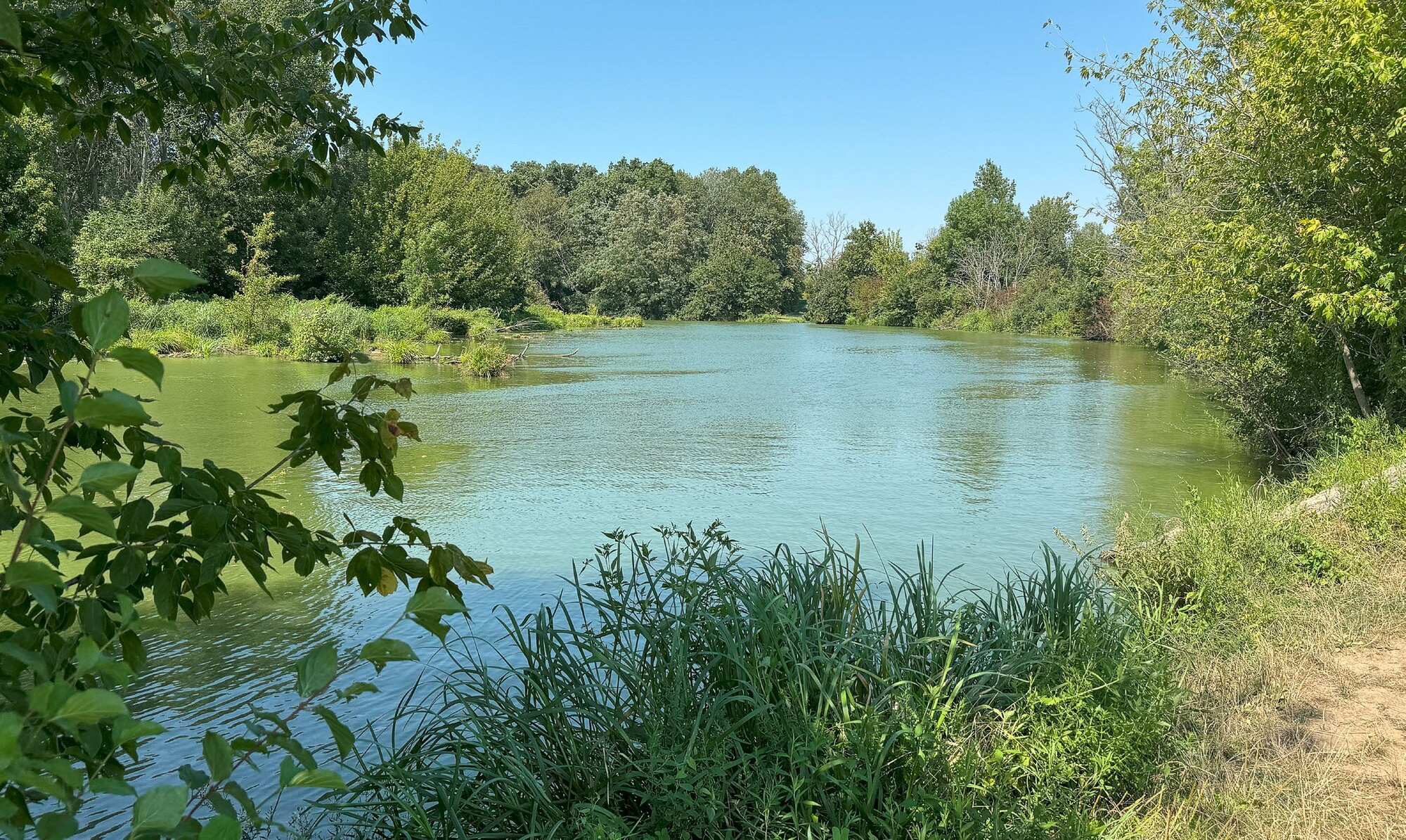
Water management interventions/modifications carried out in South Moravia during the 1970s and 1980s provided some benefits, but they also resulted into drastic changes in the area’s original conditions and character. They caused extensive environmental damage, either by the direct destruction of valuable habitats or by alterations to the hydrological regime there.
The designation of the Soutok/Confuence Protected Landscape Area (PLA) increases the chances of remedying the damage. What exactly happened in the past, and what kind of damage occurred? What might structural and hydrological measures look like, and what benefits could they bring? Drawing on the results of a water management study commissioned by the Nature Conservation Agency of the Czech Republic (NCA CR) as the basis for preparing the management plan, we offer at least brief answers to these questions.
The study is dedicated to the memory of Antonín Buček, a forester and biogeographer who devoted himself intensively to the conservation of floodplain ecosystems and who also defined the concepts of the complete dynamic fluvial successional series of floodplain habitats and the water management paradigm.
Hydromorphology of the Morava and Dyje/Thaya Rivers
Depending on local conditions, dynamic fluvial processes in river floodplains give rise to different hydromorphological river types (channel patterns), which in turn determine the associated ecosystem types. The main factors/drivers influencing hydromorphological type are discharge, gradient and the amount of transported sediment. In essence, this is an energy-related process, although varying in space and time. Each type of river pattern occurs under characteristic natural conditions, which also determine the basic spatial and morphological parameters e.g. the width of the meander belt, sinuosity coefficient, centre-to-centre distance/wavelength of successive meanders, their “radius”, etc.
Within the Soutok/Confuence PLA, the principal hydromorphological type of the Morava River and the Dyje/Thaya River is anastomosing: the branching of a meandering (Morava) or sinuous (Dyje/Thaya) channel into multiple arms within a wide floodplain subject to frequent inundation. This is a river pattern in which the river has one or more main channels while also forming numerous periodically flowing side arms that emerge and disappear over space and time.
These dynamically evolving habitats are typically associated with specially protected wild plant and animal species. The river arms also ensure the transport of water and sediment (including nutrients). Floodplain forests are crucial to the formation, development, and functioning of the side arms within this branching river pattern. In the Czech Republic, river channel branching occurs primarily within floodplain forest stands. Trees uprooted into channels, barriers formed by trunks and branches, and similar obstacles act as triggers for channel-forming processes. When floodplains are deforested and converted into meadows, anastomosing side arms may persist for some time; however, they gradually disappear over the long term.
The anastomosing system was functionally destroyed by the regulation of the Morava and the Dyje/Thaya rivers; however, the floodplain has still been preserving an entire range of gradually disappearing remnants of river arms. The mechanisms described above are abiotic factors/drivers underlying the formation of the ecosystems that constitute the subjects of protection within the Soutok/Confuence PLA.
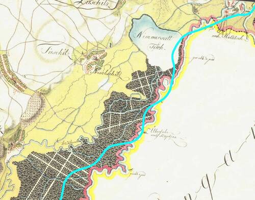
Figure 2. The Podluží ethnographic region (literally Beneath the Floodplain Forests) between the town of Hodonín and the village of Tvrdonice (South Moravia) shown on an extract from the First Military Survey.
An example of the originally relatively natural type of the river system. The main meandering channel of the Morava River forms the historical border with the Kingdom of Hungary. Floodplain forests and meadows are interwoven with branches of an anastomosing system, fed both directly from the main channel of the Morava River and from the fishpond below the town of Hodonín, Nimmersatt Teich (Nesyty). Some of the meadow channels had already been straightened. The turquoise line indicates the present-day course of the Morava River. Source: www.geolab.cz, Barbara Stachoňová
The complete dynamic fluvial successional series of floodplain habitats
The diversity and interconnectedness of floodplain ecosystems linked by complex developmental processes are best captured by the geoecological concept of the dynamic fluvial successional series of floodplain habitats. This represents a continuum of aquatic, wetland and terrestrial biocoenoses at different stages of successional development, continuously evolving in response to fluvial landscape-forming processes. Therefore, it may be considered as a system of different habitats, ranging from flowing and standing waters, through the early stages of colonisation of freshly exposed, eroded, and sedimented surfaces on river deposits, to climax forest stages.
The completeness of the series of floodplain habitats depends on the continuous action of fluvial processes. In particular, these include disturbances associated with channel migration driven by lateral bank erosion, as well as sedimentation and erosion processes occurring within the channel and floodplain during floods. The complete dynamic fluvial successional series of floodplain habitats can be maintained only by restoring natural fluvial processes in at least some parts of the floodplain landscape, thereby ensuring the spatial connectivity of biocoenoses and the continuity of their development.
The concept presents both the values and the rationale for nature conservation and landscape protection, while also defining the framework for the water management solutions required within the Soutok/Confuence PLA.
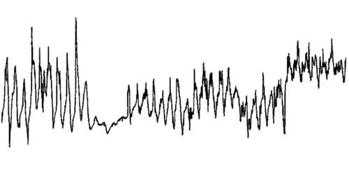
Figure 3. Kančí obora/Wild Boar Game Preserve – weekly groundwater level records from borehole KBO 710 (based on monitoring by the Czech Hydrometeorological Institute Brno) for 1961–2000. The graph shows three distinct phases of the hydrological regime: (1) the original state prior to water management interventions (i.e. regulation of the Dyje River); (2) the period following these interventions (1972); and (3) the period after the implementation of restoration measures (1995). Compiled by Alois Prax
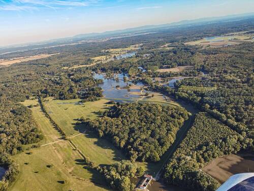
Figure 4. Pohansko weir, 22 September 2024, the day the flood peak subsided. © Adam Koukal
During the September 2024 floods, Pohansko weir (at the lower edge of the image) was not used to inundate the alluvial forest. Floodwaters are largely confined outside the polder, and the embankment paradoxically prevents Dyje/Thaya River floodwaters from spreading into the polder.
Water management interventions in the 1970s and 1980s
The system of natural watercourses and their minor modifications described above had persisted until the 1970s and 1980s, when the so-called water management interventions in South Moravia were carried out. These included radical modifications to the channels of the Morava and the Dyje/Thaya rivers, building the Soutok/Confuence polder, construction of the Nové Mlýny Waterworks reservoirs system, including modifications to the outlet reaches of the Svratka River and the Jihlava River and several smaller watercourses, as well as related infrastructure such as irrigation systems.
The measures were implemented primarily with the aim of flood protection (including the protection of agricultural land), accelerating the conveyance of flood flows through the Morava channel, and reducing peak flows in the Dyje/Thaya River through retention in the Nové Mlýny Waterworks reservoirs and the Soutok/Confuence polder. This was followed by the irrigation of agricultural land. As regards the river channels themselves, the measures mainly involved straightening, embanking, deepening, and widening, together with bank reinforcement.
The interventions brought some benefits, but they also led to drastic changes in the area’s original conditions and characteristics, a radical simplification of its morphology, and the loss of habitats used for shelter, feeding, and reproduction. They caused extensive environmental damage, whether through the direct destruction of valuable habitats or through alterations to the hydrological regime. Along the Rohatec–Soutok/Confuence stretch, the Morava River was shortened to 53% of its original length. The interventions caused drainage of the landscape through deepened river channels and disconnected the floodplain from the main channels. As a result, regular natural floods and smaller-scale inundation ceased, and both longitudinal and transverse migration barriers were created there.
Full restoration of the original anastomosing system and its associated hydrological regime has no longer been possible given existing built-up areas, current land use, and resulting constraints. The proposed measures, therefore, focus on mitigating the negative impacts described above.
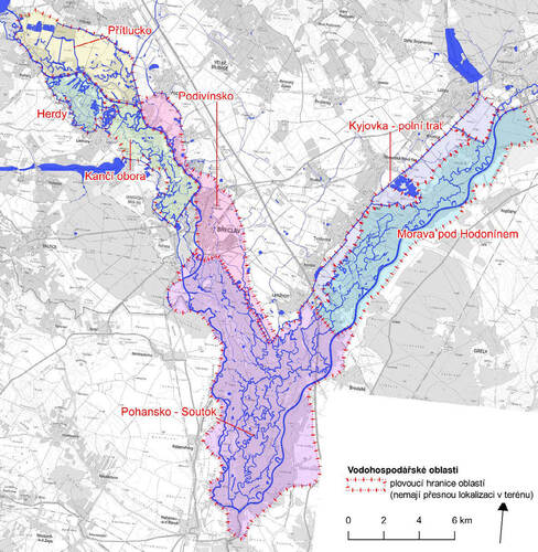
Figure 5. Delineation of water management areas. Source: Tomáš Havlíček, Barbara Stachoňová
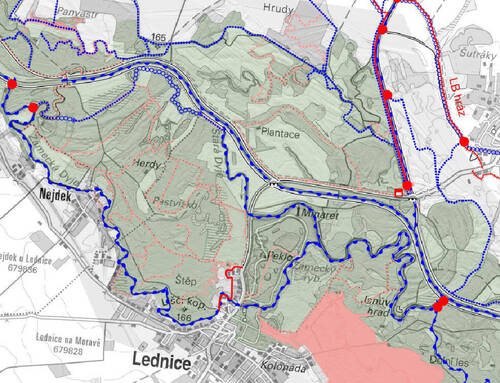
Figure 6. Extract from a map of proposed structural measures for the Herdy area. The core of the proposal is restoration of the flowing the Stará Dyje/Old Thaya River stream. A substantial part of it has still been there, but only as disconnected standing waters. Other proposals are also shown: the clearance of Zámecká Dyje/Castle Thaya River stream, the restoration of the main Dyje/Thayaa River channel, the reconstruction or proposed new water control structures, and sections of the embankment system to be restored or supplemented. Also indicated are canal systems for rewetting and an area with a proposed restoration intervention by the municipality of Lednice. Source: Tomáš Havlíček, Barbara Stachoňová
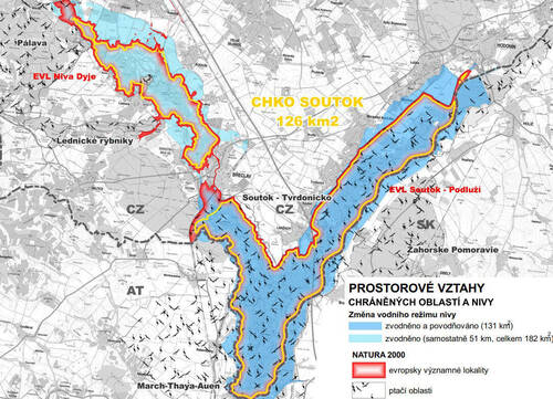
Figure 7. Effects of the proposed measures in relation to changes in the hydrological regime in the Soutok/Confluence Protected Landscape Area. Darker blue indicates flooding (high-flow conditions with overbank inundation of the floodplain, including disturbance effects). This is explicitly distinguished from rewetting, shown in lighter blue (redistribution of normal flows in favour of the floodplain). Source: Tomáš Havlíček, Barbara Stachoňová
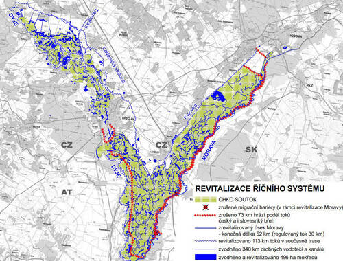
Figure 8. The effects of the proposed measures on standing and running waters consist primarily of restoring a more natural character to running waters and in reinstating smaller watercourses within the floodplain, enabling the distribution of water across the area. Source: Tomáš Havlíček, Barbara Stachoňová
Principles and objectives of the proposed measures
The Soutok/Confuence PLA is a floodplain landscape. Thus, an appropriate river system and hydrological regime are fundamental prerequisites not only for achieving nature conservation objectives, but also for sustainable forest management and other water management functions, primarily the provision of drinking water and flood protection, as well as additional benefits such as recreation.
The proposed changes are based on a critical analysis of the current system created by past water management interventions. Some water management structures have still been serving a purpose today and should be preserved and properly maintained. Other structures, however, should be reassessed for their function and design and either modified or fully removed. This approach is based on the principle that, in some cases, adapting to natural processes is more effective and less costly than attempting to control them through expensive technological measures. Therefore, the proposed measures are differentiated, inter alia, according to where and how this principle can be applied.
At the same time, the approach to the functioning and management of basic water management structures (the water management paradigm itself) is being reconsidered. Humans neither need nor can control and manage every process. Instead, natural processes should be allowed to operate freely wherever possible.
The proposed measures approach the modification or retention of the existing functioning of key water management features as follows:
Flood protection of the town of Břeclav and downstream settlements through the retention areas of the Přítluky and Lednice polders and the levee systems is to be maintained, with the existing model further developed and inflows to water abstraction areas increased.
The existence of the Nové Mlýny Waterworks reservoirs system is respected, even though their construction caused extensive ecological/environmental damage and significantly altered water management conditions. However, it will be necessary to redefine the allocation of storage capacity for different purposes (irrigation, support of minimum flows, flood protection, etc.).
The principle of using the right-bank floodplain of the Morava River and the Soutok/Confuence complex for flood protection only during extreme discharges is to be abandoned and replaced by a principle of allowing floods to spread across the entire undeveloped floodplain much more frequently and at lower discharges. This would make it possible to remove or relocate levees, fully restore the Morava River channel, and significantly alter the hydrological regime of the Morava and Dyje/Thaya river floodplains within the Soutok/Confuence polder area. Although this would mean losing the (problematic) possibility of “controlling” major floods, other functions would thereby be strengthened.
The long-term objectives of the proposed measures from the perspective of nature conservation may be defined as follows:
Restoration of a natural, or at least close-to-natural, river system as the fundamental landscape structure (structural objective). Therefore, the main means of achieving the objective will consist of interventions to remedy the impacts of past water management modifications. This objective may be further specified through seven specific requirements.
Restoration of a natural, or at least close-to-natural, hydrological regime of river floodplains as the fundamental water-management process (regime objective). The regime is characterised by discharge and the movement of surface water and groundwater. Its manifestations include floodplain inundation during high flows and more extensive floodplain rewetting during normal usual flows. Thus, the main means of achieving the objective will involve adjusting hydraulic features (channel capacity, hydraulic structures, etc.) and, in some cases, artificial water regulation. The regime objective may be further specified through four specific requirements.
Restoration of natural processes. The two objectives are linked by their mutual interdependence and dynamic variability in space and time. Therefore, the processes themselves provide the desired natural values. Landscape disturbances, as one of the principal manifestations of the processes, are not only acceptable but directly necessary for the preservation of the natural values for which the Soutok/Confuence PLA is being established.
The nature conservation objectives cannot be achieved across the entirety of the Soutok/Confuence PLA or to their full extent. The proposed measures are differentiated according to local conditions and possibilities. Nor can the proposed solutions be separated from cross-border connections, which will need to be addressed at the very beginning of further planning and implementation.
Proposed target conditions and measures for individual areas
The proposals are set up for individual water management areas (relatively self-contained water management units), each structured in the following sequence: target condition → structural measures → regime measures. Taken together, the proposed measures are a coherent overall water management concept that serves as a framework for more detailed solutions for individual structures and water management regimes. These are addressed in greater detail through proposed approaches to water management under six typical hydrological situations, ranging from low flows to flood conditions.
In the Přítluky and Podivín area, the current land use of the left-bank floodplain of the Dyje/Thaya River, together with its envisaged flood-protection (retention) function, does not fully achieve the above-mentioned nature conservation objectives. Therefore, the proposed measures aim at for at least partial fulfilment of the objectives, corresponding to the category of “halting degradation”. The main measures focus on revitalisation of the Dyje/Thaya River channel within its current course, improved rewetting of the left-bank floodplain through the restoration of small watercourses and channels, and modifications to the levee system that protects settlements. Attention is also paid to measures to improve the quality of water discharged from the Nové Mlýny Waterworks reservoirs system and to prevent fish mortality.
In the right-bank floodplain of the Dyje/Thaya River (Herdy and Kančí obora/Wild Boar Game Preserve), increased flows and spatial modifications strengthen both water management and ecological functions. However, full-scale restoration has no longer been possible. The area will continue to serve as a polder. The “minimalist” category is implemented there. The role of the Stará Dyje/Old Thaya River stream is significantly strengthened, with the continuity of its channel restored/reconnected and flow re-established from the water intake into the Zámecká Dyje/Castle Thaya stream all the way to its confluence with the Dyje/Thaya River below the Janohrad Castle. The measures also aim to enhance groundwater recharge.
The Kyjovka River was previously relocated to the foot of the Podluží river terrace and is now an artificial channel that does not allow for substantial interventions (the “minimalist” category). The proposed measures are limited to previously proposed revitalisation/restoration measures along the Kyjovka River channel and changes to the flow distribution regime at the diversion structure below Lužice. The question of whether the historic earthen field levees at the boundary between forest and agricultural land should be fully restored is left open for further decision-making.
The Morava River downstream of the town of Hodonín requires radical changes to achieve the stated objectives. The “comprehensive” category is considered feasible, whereas less extensive alternatives would not allow fulfilment of the declared objectives. The proposals envisage the removal of levees on the Czech side and, in part, on the Slovak side, together with substantial restoration of the original river system, including meanders and floodplain side arms. One of the background studies already discussed also envisages relocating levees on the Slovak side. The measures must not worsen flood conditions in the town of Hodonín, and the more detailed solutions will be adapted accordingly. Of all the main watercourses considered, this section of the Morava River is in the worst ecological condition, but surprisingly it also offers the greatest realistic possibility for restoration.
For the Soutok/Confuence PLA itself, the proposals in the “comprehensive” category envisage continuing the restoration of the natural meandering channel and side arms of the Morava River in this section as well. At the same time, they also propose the complete removal of the levee system along the Dyje/Thaya River downstream as far as the town of Břeclav, while respecting the need for flood protection. Some restoration/revitalisation measures have already been carried out on the Dyje/Thaya River (the restoration of several boundary meanders), and their completion is anticipated. The flap weir currently under construction on the Dyje/Thaya River will be completed, enabling significant changes to the flow regime and substantially improved rewetting and flood inundation of the floodplain, with beneficial effects on ecosystems and the condition of forest stands.
Conclusions
Most of the issues outlined above have already been known and have been described in various background documents. Several studies and projects have already been elaborated to address them, but they are fragmented. As part of the study, the authors taken them on board, critically evaluated, incorporated and coordinated them with other proposals. Most of the proposals included in the study have thus already been included into both the river basin management plans and the Territorial Development Principles of the South Moravian Region. The Austrian and Slovakian partners are preparing joint restoration measures on the Morava River border stretch downstream the Soutok/Confluence. Thus, the agreements with Slovakia and Austria need to be updated as soon as possible and a coordinated approach is needed. In the next phases, it will be necessary to establish the phasing schedule of the activities and to define individual investment or administrative actions as a basis for the systematic implementation of the proposed measures. The principal task is to ensure that these plans do not remain on paper. Virtual water is neither drinkable nor does it meet the needs of ecosystems.
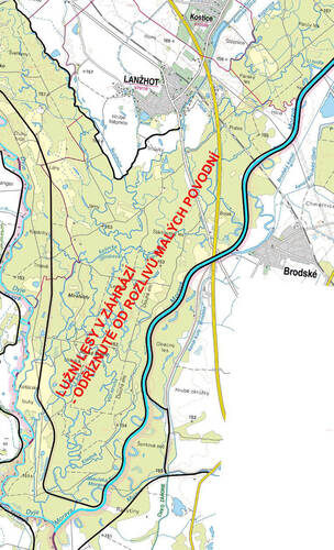
Figure 9. The embankment on the right bank of the Morava River and the set-back embankment on the left bank of the Dyje/Thaya River form the Soutok/Confluence polder. Significant flooding of the floodplain forests rarely occurs. A more natural regime would be enabled by removing the polder embankments and the embankment on the right bank towards the town of Hodonín, setting back embankments on the Slovak side, and restoring a meandering channel of the Morava River. This would enhance water retention and rewetting of the floodplain even during much smaller floods. Source: Tomáš Havlíček, Barbara Stachoňová
Several studies and projects have already addressed possible solutions, but these remain fragmented. In preparing the present study, these materials were incorporated, critically evaluated and coordinated with the other proposed measures. Most of the proposals contained in the study have therefore already been incorporated into river basin management plans and regional spatial development principles.
The Austrian and Slovak partners are preparing joint revitalisation measures for the border stretch of the Morava River downstream of Soutok/Confluence. It will be necessary to update agreements with Slovakia and Austria as soon as possible and to proceed in a coordinated manner. In subsequent phases, it will be necessary to establish a phased implementation schedule and define specific investment and administrative actions to support the systematic implementation of the proposed measures.
It is society’s responsibility to ensure that these plans do not remain merely on paper. Virtual water cannot be drunk, nor can it meet the needs of ecosystems. ■
- - - -
Cover photo: An oxbow lake of the Dyje/Thaya River below the Janohrad Castle (South Moravia).
© Tomáš Havlíček
- - - -