
Nature Conservation 2024 — 30. 5. 2024 — Nature and Landscape Management — Print article in pdf
Restoration of Meanders on the Dyje/Thaya River
The Dyje/Thaya River, together with the Morava River, is surrounded by the largest and ecologically most valuable floodplain complex of Central Europe. By straightening its course in the 1970s and 1980s, the Dyje/Thaya River was shortened by nearly 3.2 km. At the same time, dikes preventing floodings were built on both banks along the state border stretch of the river. These measures had to stabilise the border between Austria and Czechoslovakia on the one hand, and to ensure prevention and control on the other. The whole border stretch being 16.5 kilometres long was for a long time closed by the Iron Curtain. After the above water management measures, there were more than 20 remnants of the original river bed were preserved in the floodplain: these are backwater river branches/cut-off arms or oxbows of various character. Over the years, however, all these fragments of the original Dyje/Thaya riverbed became strongly silted, thus developing themselves towards a rapid termination. The modified river bed caused by puncturing the branches displayed low morphological value and straitening the watercourse contributed to accelerating water outflow from the landscape there. From a point of view of climate change adaptation, this was an unsatisfactory situation. Therefore, the river management authority proceeded to restoration measures.
Thorough preparation
Initially, an extensive study had been made assessing the cut-off arms in terms of their potential and suitability for reconnection to the watercourse. Based on the study, the most appropriate arms were selected. Various options of reconnection were considered. It had been shown that the variant of opening up both ends of the oxbow only does not produce good results. The method was used for oxbow D18 on the Austrian side, but its upper part soon become completely silted. A special challenge in connecting oxbows was the border between both states, which runs through the middle of the Dyje/Thaya River. Thus, a change in its course would also mean a change in the state border. For this reason, full integration, simulating the situation before the straightening of the course and leading to the punctures filling up practically completely, cannot be used. In order to preserve the state border while the river could regain its meanders, a completely new, innovative solution had to be found.
Therefore, the original punctures remain preserved and are only dammed off with objects that divide the water into the restored arms in a ratio which does not cause a change in the border. The approach, whereby only a necessary part of the flow goes into the arm and the river splits into two branches, has acquired the name ‘ecological integration’. The dividing object has a unique structure. It consists of a low stony step with a wide crown, which secures particularly the division at low flow rates, and narrows the flow on both sides (aptly called ‘Schlitz’ in German), ensuring the flow directions during floods. Based on a study of historical maps (1st and 2nd Military Mapping carried out in the former Czechoslovakia) we have found that this method apparently corresponds even better to the original morphology of the river, whose riverbed branched in many places. In the end, the originally restricting condition of the state border thus forced us to find a better solution.

The state of play before implementing the measures, vanishing river arm D9, Morava River Basin Management Authority © Vladimír Husák

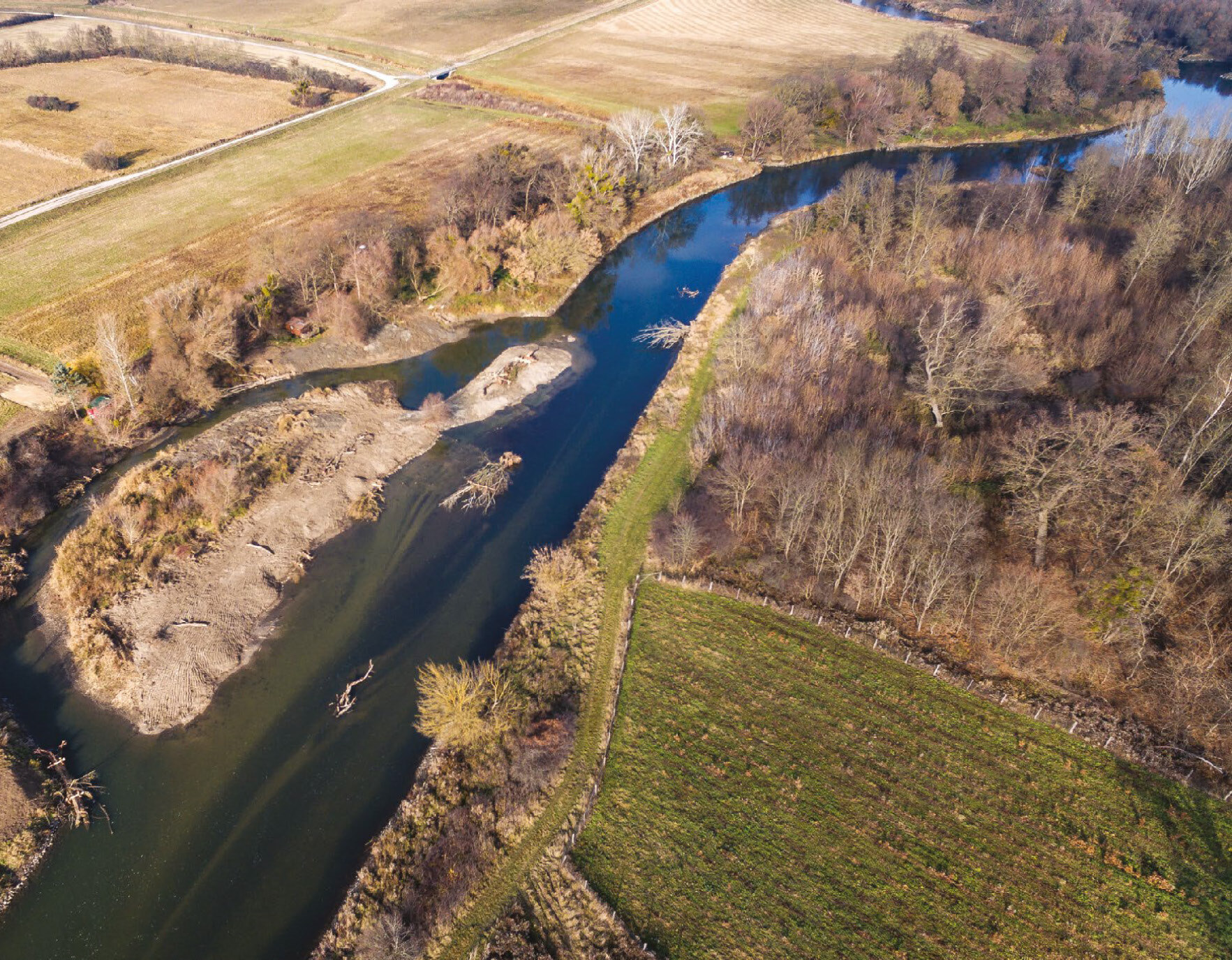
Increased flow rates, reconnected river arm D9, Morava River Basin Management Authority © Vladimír Husák

The state of paly before implementing the measures, silted river arm D18, Morava River Basin Management Authority © Vladimír Husák

New Dyje/Thaya River arm D18, Morava River Basin Management Authority © Vladimír Husák
In the first stage, two arms were connected to the river, D18 on Austrian territory and D9 on Czech Republic’s territory. The two arms were connected according to the same principles in both the countries. By full connection we mean ‘ecological integration’, i.e. the opening of both ends of the arm and inserting a dividing object into the original puncture. In addition, the small D8 arm, which forms a joint unit with the Czech D9 arm, was connected unilaterally on the Austrian side. Besides the connection of these arms, the project included the creation of a wetland communicating with the river at increased flow rates, and the formation of terrain elevations from excess soil.
The importance of these elevations can be seen during floods. The original elevations are actually a part of the floodplain forest which mostly stay dry even at high flow rates. They are the remains of the tops of sand dunes which were deposited there by the wind in colder periods of the late Tertiary, when the floodplain was much more diverse and lacked woody vegetation. In the past, the elevations rose up to 10 metres above the surrounding terrain, and provided sufficient space for the first settlers in the floodplain. In the early 13th century, with the arrival of floods bringing large quantities of material from higher elevations, terrain unevenness in the floodplain began to level out. Today, the elevations rise above the surrounding terrain by just a few metres. However, water has still been not reaching the tops of some of them during flooding, and thus provide refuge to forest animals, which may be trapped in a limited space for several days. The presence of non-forested elevations in the floodplain forest causes the occurrence of species associated with desiccating and poor soils. Unfortunately, in the recent past, some of the original elevations were planted with the Scots pine (Pinus sylvestris), which is accustomed to poor, sandy habitats and achieves high growth there. However, this has resulted in a decline in species richness/species diversity. It is therefore important to return the open elevations into the floodplain landscape, which is what our project also tried to achieve.
Important further stages
In 2022, a second stage followed, when ‘ecological integration’, i.e. the opening of both ends and the insertion of a dividing facility, was carried out at another four arms, namely D1, D2, D5, and D12. All these connected cut-offs are located on the Austrian side. It was therefore a matter of building a dividing facility up to half of the border course on the Czech territory. The design is similar to that of the first stage, except for the dividing facility which is integrated better into the floodplain landscape. The narrowing of the stream by steel sheet piles is completely covered by a structure made of wood and earth resembling a high natural bank with a tangle of exposed roots. On the Czech Republic’s territory, Dyje/Thaya River cut-offs D13, D14, D16, and D17 were cleaned without connecting them to the river. Some of these will, however, additionally be connected in the third stage, which is planned to start at the end of 2023.
Thanks to the connection of the longest oxbow on the Austrian side – meanders D18 and D9 on the Czech side – the Dyje/Thaya River course has been extended by more than 1.5 kilometre. The arms D1, D2, D5, and D12 added almost more two kilometres to that, and thus the Dyje/Thaya River regained the complete length losing during the adjustments, and at the same time also the typical lowland river character was restored there. One must imagine that each metre of riverbed returned to the river represents a safeguard to overcome drought periods better. By this length, the chance of surface water to saturate the groundwater is extended. During the recording of a radio report on the reconnection of river arms, the reporter came up with an idea that I like to use there, namely that we actually put brakes into the watercourse, which slow down the water and allow it to blend better with the surrounding landscape.
Reconnection of cut-off arms is an important element of the new approach in the Dyje/Thaya River management in the border segment, which water management authorities on both sides of the border have agreed on. The project expects a further spontaneous morphological development of the river, and first experiences has been already showing that the river has gratefully accepted this option. The local near-natural stabilisation of the riverbank in places which run parallel to important linear constructions gives water management authorities the room to accept this development without fear.
Already during the construction work, shortly after the first arm was connected, and subsequently after the entire first stage was completed, the Dyje/Thaya River was faced with two spring floods. The response of the morphological processes not only in the reconnected arms, but also in the original puncture, was unexpectedly positive. The river willingly accepted the new patterns, and morphological structures absent in that river section until then were formed in the riverbed. Gravel banks and alternating depths and shallows in fords now add to the character of the lowland river. The story was repeated during the second stage. Neither then did the river want to stay behind, and also in spring in 2023, the newly connected arms were faced with a two-year flood. We have not been able to survey the river before completion of this article in order to see how the extreme flow rate has affected the river morphology. However, it is clear from aerial photographs that the facilities fulfilled their function just exemplarily. We are looking forward to seeing which new morphological structures the flooded river has left behind.
Reasons for optimism
Little time has passed for an overall evaluation. Simultaneously with the construction work, however, ichthyological monitoring was carried out. This shows that fish missing from the straightened river can find new habitats in the reconnected river arms as well as in the revitalised puncture. The new course has also been welcomed by paddlers looking for a natural river full of romantic recesses in the Dyje/Thaya River stretch and do not mind trees lying partly across the river. They also like to make stops at gravel deposits.
The project has demonstrated that nothing is impossible if you have a vision and sufficient determination. Accept problems as a challenge and you will achieve a better solution thanks to the difficulties than you had initially hoped for. Looking at the restored sites during normal spring flows, it appears to us that the landscape is suddenly full of water. During a two-year flood, the entire floodplain area between the dikes is flooded with water, but even there, the arms do not disappear and create a new morphological structure which returns the lost diversity having been lost for a long time to the river ecosystem. The project is, inter alia, an important example of good transboundary/bilateral cooperation. It contributes positively to the water regime in the entire lowland floodplain and the adjacent riparian forest. And it is probably needless to remind the positive impact on biological diversity and self-purification ability of the river, and the overall morphological situation. ■
- - - -
Cover photo:
Connection without dividing facility, river arm D15, Morava River Basin Management Authority © Vladimír Husák